travel

World Photo Day + Architectural Photographers by stephanie calvet

World Photo Day hosted its first global, online gallery in 2010 with the goal to unite local and global communities in a worldwide celebration of photography. This year's event, held August 19th, marks the 175th anniversary of the first permanent photographic process patented and freely released to the world on August 19th, 1839. It encourages businesses, organizations and social groups across the world to leverage the power of photography by engaging their communities as part of a worldwide photography celebration held over August.

The gallery is open for submissions between August 19 - 26. Upload away!

In honour of World Photo Day 2014, ArchDaily, an online source of architectural news and inspiration, posted  "The 13 Architecture Photographers to Follow Now." Here is a small sampling from the talented bunch...

Awasi Hotel, San Pedro de Atacama, Patagonia. Architect: Felipe Assadi & Francisca Pulido. Photo by Fernando Alda.

Hotel Eso, Atacama Desert, Chile. Architect: Auer + Weber. Photo by Erieta Attali.

Guangzhou Opera House. Architect: Zaha Hadid Architects. Photo by Iwan Baan.

Edificio de Viviendas con Proteccion Publica. Olalquiaga Arquitectos. Photo by Miguel de Guzmán.

MIT Media Lab, Cambridge. MA. Architect: Maki & Associates with Leers Weinzapfel. Photo by Anton Grassl.

Shaker Heights Private Residence, Ohio. Dimit Architects. Photo by Brad Feinknopf.

Natural Swimming Pool, Riehen, Switzerland. Architects: Herzog & de Meuron. Photo by Leonardo Finotti.

Casas na Praia da Baleia, Sao Paulo, Brazil. Architect: Studio Arthur Casas. Photo by Fernando Guerra.

Museo de la Evolución Humana, Burgos, Spain. Architect: Juan Navarro Baldeweg. Photo by Thomas Mayer.

Serpentine Pavilion, London, UK. Architect: Smiljan Radic. Photo by Cristobal Palma.

Vitra Haus, Weil am Rhein, Germany. Architect: Herzog & de Meuron. Photo by Fran Parente.

Photo by Christian Richters.

Rey Juan Carlos Hospital, Móstoles, Madrid. Architect: Rafael de La-Hoz Castanys. Photo by Duccio Malagamba.

Doha sights and sounds by stephanie calvet

I've been fortunate to have the opportunity to spend time in the Middle East. First stop: Doha, Qatar. The next photos are of the Souq Waqif. The labyrinthine market looks deceptively ancient. Although the site dates back 100 years, it has recently been restored to revive the memory of the area. Over the years, the market fell into disrepair and was abandoned as shopping malls grew - and they grew, big-time. Now, the cobbled lanes and whitewashed buildings, made using traditional Qatari architectural elements such as mud rendered walls and exposed timber beams, look to be from a bygone era. Restoration or reconstruction? I'm not sure.

Souq Waqif_Doha

Souq Waqif_Doha

The shopping destination is renowned for selling traditional garments, spices, handicrafts, and animals (alarmingly, lots of dyed pets). Each narrow, covered alley sells a different commodity. I expected to see people haggling over a sale but it was all very civilized, probably because Qatar has the highest per capita income on the planet. There are shisha lounges, galleries, luxurious boutique hotels and Egyptian, Iraqi and Lebanese restaurants. There is also a Falcon Souq nearby (apparently falconry is a big hobby for Qatari men) and a camel pen in the parking lot.

Souq Waqif_Doha

Souq Waqif_Doha

Souq Waqif_Doha

Souq Waqif_Doha

Souq Waqif_Doha

Doha_Souq Waqif

These next shots are of Hey'Ya: Arab Women in Sport, an exhibition celebrating female athletes - amateurs to Olympians - from the Arab world. It featured a series of large portraits of sportswomen from 20 different countries by French celebrity photographer Brigitte Lacombe.

Arab Women in Sport_Katara

Doha_sights-10Arab Women in Sport_Katara

Next up:  Katara. It is home to a bunch of institutions including the Doha Film Institute, the Qatar Philharmonic Orchestra and the Arab Postal Stamps Museum, connected by a network of lanes shaded with wide-stretched canvas canopies. Katara seeks to promote cultural awareness and acceptance by organizing festivals, exhibitions, seminars, and all forms of artistic expression in this newly created "cultural village" beside the sea...

Katara_Doha

Katara_Doha

Katara_Doha

Katara_Doha

Katara_Doha

Katara_Doha

Katara site plan

Open to the sea stands a gargantuan marble amphitheatre, presumably used for concerts and performances. I saw a total of 3 people exploring the vast complex when I visited (not counting a bevy of golf cart drivers). All of this in the blazing Gulf sun ... I couldn’t help wondering who this is actually for.

Katara amphitheatre_Doha

Building has been going strong in Qatar. It has seen the development of new residential areas, new ports and airports, as well as  lots of new infrastructure. There is even more envisioned for Katara -- Phase IV will be a mixed-use development as an extension to the Cultural Village.

Katara Phase IV

Firá (Santorini) by stephanie calvet

Santorini_Fira-4 Santorini_Fira-3

Firá covers Santorini island’s volcanic edge with layer upon layer of hotels, cave apartments, infinity pools and swish restaurants, all backed by a warren of narrow streets lined with bars and shops. It is a vision of dramatic cliffs and low-lying cubical buildings made of whitewashed local stone.*

The town’s small scale doesn’t deter the cruise ships from all over the Mediterranean and Aegean seas that descend upon the Old Port. Its central location makes it a good base to access many other parts of the island. Fortunately, in the early evening the multitude of passengers return to their vessels and the local restos and cafés taken on a more relaxed atmosphere.

Santorini_Fira

Santorini_Fira-2

Built on the edge of a 400m high caldera on the crescent-shaped island’s western side, Firá is accessed from sea level by a cable car, donkey ride, or by foot (587 steps) along a meandering rocky path (trafficked by donkeys).

Santorini_Fira-5

Santorini_Fira-12

Christoforos Asimis is regarded as one of the island’s most significant artists. For seven years he created luminous religious paintings that fill the interior of Firá’s Cathedral after it was rebuilt following the area's major earthquake of 1956.

The newly established AK Asimis Kolaitou Art Foundation (pictured below) brings together the work of the revered Santorinian artist as well as that of his partner, Eleni Kolaitou (sculpture & jewellery).

Located on the main road from Firá to Pyrgos, the gallery opened its doors early this summer. Designed by son Katonas, who also exhibits his paintings on site, the building features the artists’ residence, studio, and indoor exhibition spaces as well as outdoor venues for music, drama or various performance art events. I had the unique opportunity to interview the family of artists. Here is a video showcasing some of their work.

Santorini_Fira-6

Santorini_Fira-7

Santorini_Fira-8

Santorini_Fira-9

Christoforos Asimis’ paintings (above) explore the magnificently changing light and landscape of the artist’s home town. It is not difficult to find a lifetime's worth of inspiration here. Island bliss.

Santorini_Fira-10

Santorini_Fira-11

*or limewashed with various volcanic ashes used as colours

Oia – Santorini’s jewel by stephanie calvet

Santorini_Oia Unfolding along volcanic rocks, the traditional village of Oia extends for almost 2km along the northern edge of the caldera that forms the island of Santorini.

The topographical particularity of this locale is staggering. Santorini’s central part collapsed as the result of a big volcanic eruption in 1660 B.C, forming this imposing cauldron-like feature. Oia can be reached by a road that meanders atop steep cliffs along the eastern periphery of the island. Sections of this road become so perilously narrow and ridge-like that it can barely accommodate two lanes of traffic. Perched 70-100m above sea level, Oia itself is divided by the central road into two sections: one facing the caldera cliff, characterized by white-painted dwellings, once used by seamen, carved into niches in the rock; and the other, a wide swath of largely agricultural land marked by conventional houses.

Orthodox Easter celebrations in Oia

Santorini_Oia-5

The ground is composed of successive layers of fragments and lava. The uppermost layer consists of pumice stone and a sub-white ash called ‘theraic earth’ that is easily excavated and gave rise to an underground cave habitation pattern with vault-like spaces receiving light from small openings on the built-out front. Many of the simple seamen's houses have become guest homes, hotels and restaurants, with narrow passageways running between them.

Santorini_Oia-8

Santorini_Oia-7

Oia seduces visitors with its blue domed churches, sun-bathed verandas, and quaint cobbled alleys lined with taverns and shops. But most of all, it is renowned for its enchanting sunsets, best experienced at the ruined castle at the tip (above).

Santorini_Oia-3

Santorini_Oia-9

A differentiating architectural element in the island’s vernacular is the vaulted roof of dwellings that resulted from their subterranean typology. It became more common after strong earthquakes in 1956 struck the island and destroyed or damaged half of its buildings. Restrictions to new construction have been put into place in order to minimize risk from future earthquakes and to preserve and restore – or find new uses for – traditional settlements.

Santorini_Oia-11

Krinaki restaurant, Finikia

A number of unfinished construction sites dotting the Aegean landscape stand in watchful reminder of the harsh economic winds affecting Greece.

Santorini_Oia-12

Touring Cappadocia by stephanie calvet

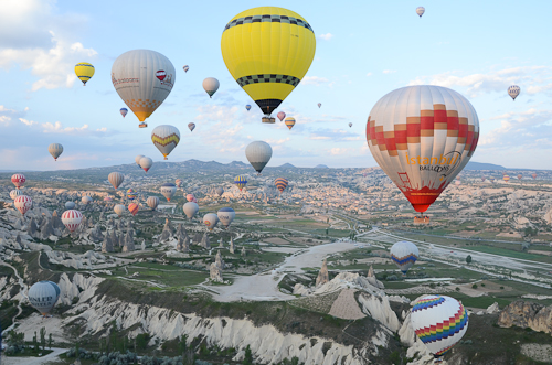
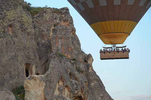
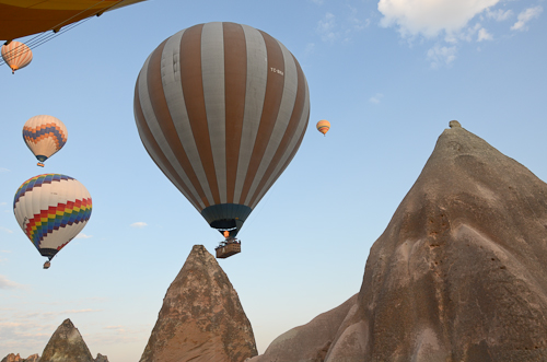
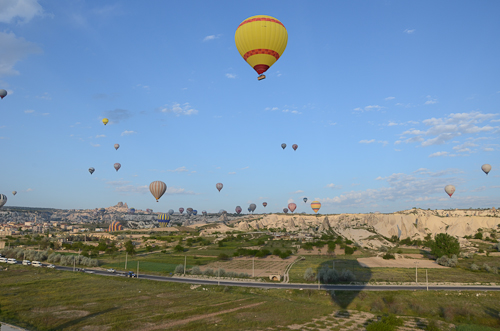
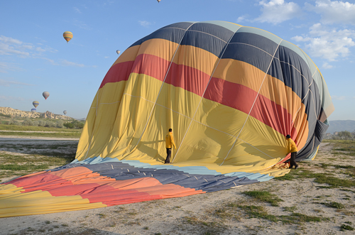
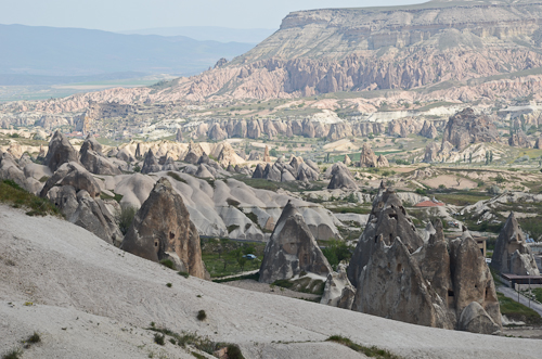
Cappadocia is the historical name of the region in Central Turkey, 750 km southwest of Istanbul and 300 km south of Ankara. Modern Cappadocia refers to a geographical area with a unique cultural heritage and landscape entirely sculpted by erosion, whose exceptional natural wonders are a popular setting for a variety of activities such as hot air ballooning (see previous post), horseback riding, and guided area tours, some of which are described here. One such outing is a hike in the Ihlara Valley, a picturesque canyon marked by a stream that flows through it and honeycombed with hundreds of rock-cut underground dwellings and cave churches from the Byzantine period. The rock-hewn sanctuaries contain colourful frescoes, some still remarkably intact.

Ihlara Valley gorge

Ihlara Valley_Melendiz StreamIhlara Valley_stairway up

Ihlara Valley_St George Church

The Underground City of Derinkuyu is an ancient multi-level complex used by early Christians as a hiding place during times of raids, before Christianity became an accepted religion. The vast network of caves sheltered up to 20,000 people and livestock for months at a time. Carved into the soft volcanic rock, its passages extend to a depth of 60m and are connected to other troglodyte villages or subterranean towns through miles of tunnels. Though breathing is difficult, you can descend as far as the 5th level to visit once-occupied spaces, such as chapels, religious classrooms, cellars and stables.

Derinkuyu Underground City

Other memorable spots include Selime, whose dramatic topography (pinnacles) inspired some of the filming of ‘Star Wars’, and Pigeon Valley, named for countless pigeon dwellings carved into the cliffs. (Years ago these creatures served as message carriers, and their droppings were used as fertilizer.)

Panoramic viewpoints of Paşabağı and Devrent Valley reveal mushroom-shaped fairy chimneys and unusual eroded landforms whose volcanic tuff has been sculpted into shapes shapes reminiscent of pillars and spires and even resembling animals – a 'lunar landscape' - like a  sculpture zoo made by nature.

Cappadocia-area-tours-7

Paşabağı fairy chimneys

Cappadocia-area-tours-2-3

Göreme Valley_Göreme Suites hotel view

Cappadocia-rock formationsThe town of Avanos is the center of ceramic art and earthenware production and trade dating back to the Hittites, and here you can see a pottery-making demonstration by kick-wheel technique.

Avanos_Destiköy

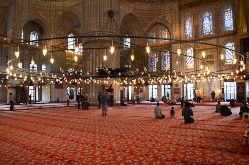
Sema, the Whirling Dervish Ceremony, is a physically active meditation still practiced by the Dervishes of the Mevlevi order. They aim to reach the source of all perfection by performing a customary dance, of which each of its seven parts symbolizes a stage of the mystic journey called ascension. Cloaked in a white frock and headdress, the Dervishes listen to music, focus on God, and, in a trance-like fashion, spin their body in repetitive circles, revolving as do all other beings and embracing humanity with love.

Cappadocia-whirling dervish ceremony

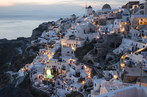
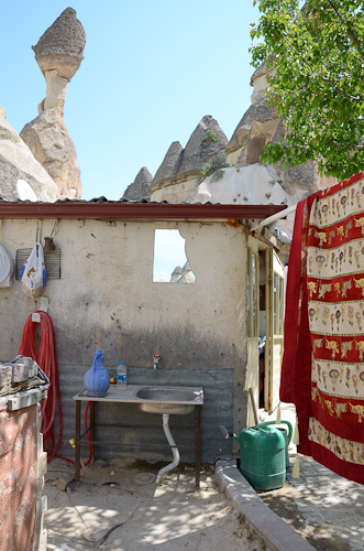
At the centre of Cappadocia are the towns of Ürgüp and Göreme. Within the region's rock formations, Christian villagers had excavated cells which served as residences, storage, places of worship and refuges dating from the 4th century. It’s a very special experience to stay in a hotel built into existing caves, one that combines dwellings of the Hittite, Roman and Byzantine periods with the comforts of the 21st century.

Cappadocia cave hotel_Garamisu

Cappadocia_Göreme-1

Cappadocia_Göreme

Cappadocia_Göreme

Cappadocia_Göreme-detail

Cappadocia_Göreme-new hotel

Cappadocia_Göreme-new hotel

Göreme National Park and the Rock Sites of Cappadocia have been included in the UNESCO World Heritage List. See link here.

Hot Air Ballooning in Cappadocia by stephanie calvet

Hot air ballooning in Cappadocia, a historical region in Turkey's Central Anatolia, yields breathtaking views, unrivaled anywhere. Balloons launch just before dawn, dozens at a time.  They float silently above surrealistic landscapes dotted with villages, vineyards and fruit orchards. The balloon gently drifts over and between tall, thin  rock formations or 'fairy chimneys', through valleys and up over rippled ravines, before touching down in a farmer's field.

Cappadocia_hot air balloons-2

Cappadocia_hot air balloons-3

Cappadocia_hot air balloons-bird's eye

Cappadocia_hot air balloons-5

Cappadocia_hot air balloons-6

Cappadocia_hot air balloons

Cappadocia_hot air balloons-7

Cappadocia_hot air balloons-8

Cappadocia_hot air balloons-9

Cappadocia_hot air balloons-10

The Bay of Fundy by stephanie calvet

Little known fact: Each day over 100 billion tonnes of seawater flow in and out of the Bay of Fundy during one tide cycle – more than the combined flow of the world’s freshwater rivers.”*

The highest tides on the planet are found in the Bay of Fundy, a 270km-long ocean bay that stretches between the eastern Canadian provinces of New Brunswick and Nova Scotia. The time between a high tide and a low tide is approximately six hours. And so twice a day, every day without fail, the tides recede and expose the vast ocean floor.

There are exceptional sites in Nova Scotia from which to observe this ecological phenomenon. Five Islands Provincial Park is a spectacular setting for camping and ocean kayaking. At low tide you can walk the seabed and dig for clams in mud flats or comb the beach for fossils and other marine curiosities. And, for the rock enthusiasts, some 225million year-old geological formations –overhanging cliffs and caves eroded by the water's impact through the millennia – are ever so patiently waiting to be explored.

Cape Chignecto Provincial Park is a wilderness-hiking park on a coastal peninsula. Trails sweep through an old-growth forest ecosystem, scale canyons and valleys, and climb towering cliffs where waves lap their base. They pause to reveal dramatic vantage points from where to view the semidiurnal tidal action, whose times and heights vary from one location to the next. (The water rises and falls around the Bay in elevations ranging from 3.5m to 16m, securing the title of World Tidal Dominance!) In Cape Chignecto, there are single or multi-day trails to hit, many of which descend at the beach. Some are so challenging, only the highly skilled should attempt. Consult tide charts in advance for accurate times in order to coordinate a return trip back along the shore. A high tide may delay or worse, leave one perilously stranded along the beautiful yet rugged terrain...

Nova Scotia - The Cabot Trail by stephanie calvet

Cape Breton … stunning natural beauty in a rugged coastal setting, untamed by habitation. Sure, there are small Acadian towns, fishing villages and the odd tent pitched along the way. But the land is vast and dramatic. Where is everybody? There is more than enough for everyone here.

The route winds over mist-laden mountain peaks and valleys, bestowing spectacular views of ocean or lake each and every which way you look. The Cabot Trail is a 298km scenic highway that loops around the island of Cape Breton, a forested plateau bordering the Atlantic. It passes through the Highlands National Park and follows the shoreline of this northernmost tip of Nova Scotia. Rolling out in front of us, the roadway changes from red to green to lavender.

A holiday here is a vacation in the truest sense of the word. There is a quality that engulfs the senses, a serenity that stirs the soul. If not by car, visitors travel by bike, kayak or on foot. Walking trails – 5, 10, 20km long – wind their way through forests and skirt the edge of actively eroding cliffs. The cool, maritime climate and rocky landscape allows for a blend of northern and temperate species of plants and habitats. We share wild berries with the wildlife – if we’re lucky to beat ‘em to it – and enjoy a bounty of fresh seafood at every meal. Gastronomes know how wonderfully scallops and halibut pair with the sweet local wines. There is no shame in admitting it: we’re eating & drinking our way through Nova Scotia.

And water is everywhere. Our Zodiac skims past caves and rock outcrops near the coastline, then fearlessly darts out to deep sea in search of whales. The wait is a short one. The vessel grinds to a halt upon tracking clusters of the migrating mammals. Left and right, we catch glimpses of their glistening skin slipping out from under the surface. Buzzing around us, some whales boldly approach close enough to touch but mostly we watch their breaching from afar, how they expose their fusiform-shaped bodies or slap their tails before submerging again. The numbers that I haven’t seen here in people I see in animals – a generous quota – which also includes dolphins, seals, turtles, eagles, puffins and other seabirds.

It is delightful to not be vacationing with the masses this summer. We have the road and beach to ourselves. Fine folk (like the P.E.I. sisters above) who too have chosen Nova Scotia as their retreat of choice stay in cottages and campgrounds sprinkled throughout the region while some of us prefer to slum it up in charming B&Bs and resorts. Like the motorcyclists travelling in packs, we choose the solitude of the open road. It’s all very civilized out here…